
Summit Ski Tours
From easily accessible peaks to airy summits – find your ski touring adventure in the mountains at the gateway to Jotunheimen.
Welcome to the mountains!
Tyin Filefjell is an area where many summit tours are close together, and access to the mountains is easy.
Several tours start with a short approach from the road, and some can be done directly from accommodations like Filefjellstuene. In addition, a number of summit tours are within a short driving distance along E16 or Fv53 Tyin–Årdal. This makes it easy to choose a tour based on weather, snow conditions, and skill level, without the need for long transfers.
Ski Touring Routes in the Area – from Easy to Challenging
The area is well-suited for beginners, with several short tours in clear terrain. This makes Tyin Filefjell a great place for an introduction to summit touring – also for families who want to try it together. Several of the tours have a steady ascent and distinct terrain formations, making it easier to create good experiences for both young and old. At the same time, there is a wide selection of summit tours for the more experienced, both in the immediate vicinity and with short distances to more alpine destinations towards Jotunheimen.
For those who wish to develop their skills – or undertake longer and more demanding tours – courses and guided tours are also offered in the area. This provides an opportunity for safe travel in the mountains, with local guides.
The short distance between destinations also provides flexibility throughout the day. It's possible to complete short hikes before breakfast, or fit in a summit tour after a day on the slopes.
The summit tour season at Tyin Filefjell is often long. With its high altitude and stable snow conditions, there are good opportunities for summit tours from early winter and well into spring, and some years even into early summer.


Important information!
During ski touring, you may enter areas where avalanches can occur, and a safe trip requires that you make your own assessments both before and during the tour.
Before embarking on a tour, you must familiarize yourself with the current conditions. Check the avalanche forecast on varsom.no, and assess the weather, wind, and snow conditions. This provides a better basis for choosing a route that suits both the conditions and your own experience level.
Route selection should be adapted to both terrain and skills. Even short tours can pass through areas that require ongoing assessments, and it is important to be prepared to adjust your plan if conditions warrant it.
Also ensure you bring the necessary equipment. For summit tours, this includes avalanche gear such as a transceiver, probe, and shovel, as well as clothing and equipment adapted to the weather and activity. Remember that not only avalanches can be dangerous, but also hypothermia if the weather changes, or if you are unlucky and injure yourself or your equipment.
Visit varsom.no

Summit tours directly from your hotel room
Stay where the mountains begin – with short access to the peaks and long days on skis. From Filefjellstuene, it's possible to embark on several summit tours directly from your door, without the need for transportation.
Using Slope Angle Maps
Slope angle maps are a useful tool for planning summit tours, providing a visual overview of the terrain's shape. The maps show the inclination of the landscape, making it possible to identify areas prone to avalanches, as well as how far a potential avalanche might reach.
As a rule of thumb, terrain steeper than 30 degrees is considered “avalanche terrain,” as most avalanches release from this inclination or steeper. By using slope angle maps in planning, one can therefore more easily find routes that follow gentler terrain, avoid steep slopes, and identify alternative routes if conditions warrant it.
At the same time, it is important to be aware that slope angle maps do not show smaller terrain features. The map also does not provide information about snow conditions, layering in the snowpack, or how stable the snow is. Therefore, it must always be used in conjunction with updated avalanche forecasts and your own assessments during the tour. In other words, slope angle maps are a good support tool – but not a definitive answer.
Slope angle maps and the avalanche forecast can be found on the Varsom app.
Read about the "Varsom" app
More opportunities when Tindevegen opens
When Tindevegen opens for the season, there will be short access to new summit touring areas west of Tyin Filefjell. The road between Øvre Årdal and Turtagrø is normally open from May to November, providing easy access to Hurrungane and several alpine destinations in Jotunheimen. For many, this marks the start of the spring ski season, with longer days, greater terrain variation, and more opportunities within a short driving distance from Tyin.

Summit tours with a guide
Here you can get a taste of a guided summit tour with Tau og Tind (formerly Tyin Aktiv). Local guides will give you the best tour experience!
Courses and guiding in the mountains
Tau og Tind offers both introductory courses and guided tours for all levels.
On a summit touring course, you will learn to use skins, ascend efficiently, and descend safely in various snow conditions. The courses take place in small groups with a focus on practical application, ensuring that everyone receives close guidance from experienced, local instructors.
Even experienced skiers can benefit from further learning. Tau og Tind regularly offers avalanche courses where you learn about snow conditions, avalanche assessment, and practical use of avalanche equipment – knowledge that makes your trips both safer and better.
If you prefer a trip over a course, you can join a guided summit tour. This allows you to experience the most beautiful mountains without having to worry about route selection or avalanche assessment. Our guides know the area inside out and tailor the trip to your level and preferences – whether it's a relaxed hike to Stølsnøse or a longer day trip towards Jotunheimen.
Tau og Tind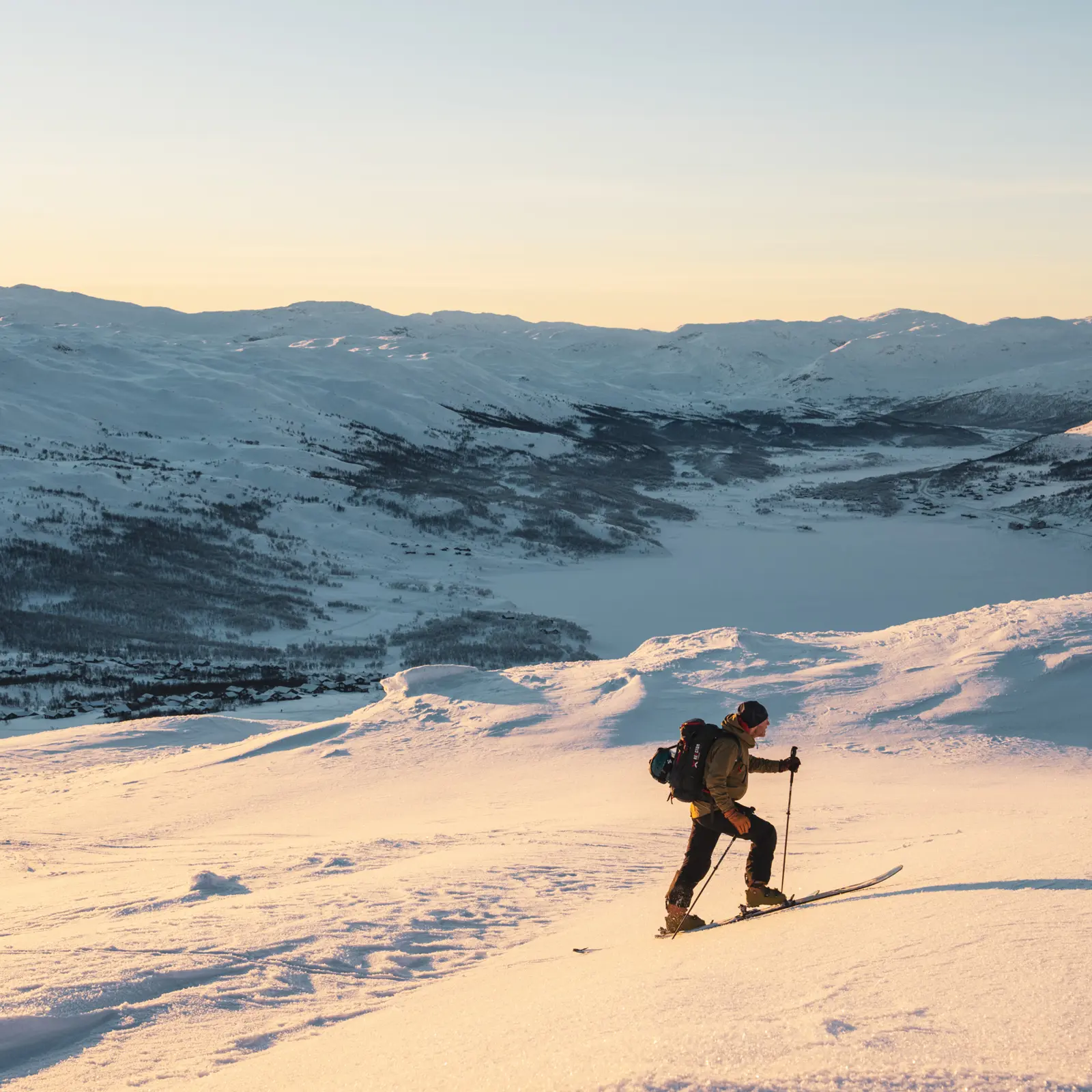
Frequently asked questions about ski touring at Tyin Filefjell
Here we have gathered practical information and common questions about ski touring at Tyin Filefjell – so you can prepare well and look forward to the mountains.
You’ll need skis with climbing skins and a walk mode (randonnée skis), boots that can be loosened at the ankle, poles, and full avalanche safety gear (transceiver, probe, and shovel). Dress in layers and wear windproof outer clothing – the weather can change quickly in the mountains.
Don't have all the equipment yourself? You can rent ski touring skis and avalanche safety gear at the ski rental at Tyin Filefjell Skisenter.
The peak ski touring season at Tyin-Filefjell usually begins in November or December and lasts until May – sometimes even longer. The main season runs from January to April, when the snowpack is more stable and the days are longer. Before heading out, always check the snow conditions, weather forecast, and avalanche warnings.
Yes, as in all mountain areas there can be a risk of avalanches. Always check the current avalanche warning at varsom.no before your trip. Avoid terrain steeper than 30 degrees if you’re unsure, and always carry an avalanche transceiver, probe, and shovel – and know how to use them. Consider joining an avalanche course or a guided tour to learn more.


